

The Greek Pilot area extends along the coastal zone, on both sides of the Nestos River. Nestos river is a transboundary system, originating from the Rila Mountains, in central Bulgaria, crossing the mountainous terrain of Bulgaria, and then entering Greece, passing through the protected Nestos Gorges and eventually discharging to the Thracian Sea, in Northern Greece. The river forms a significant ecosystem throughout its course, whilst at the deltaic zone a floodplain is formed, covering approximately 440 km2. Coastal and riparian wetlands form a unique natural ecosystem protected by the Ramsar Convention. The coastal zone’s total length is estimated at around 50 km. Along the western part of the coastline, a complex system of lagoons (Vassova, Eratino, and Agiasma lagoons) is situated; to the center, the Keramoti gulf and the western Nestos River delta; and to the east, the eastern Nestos river deltaic zone and two of the most popular beaches in Thrace (Maggana and Myrodato).
The sediment transport to the coastal zone is mainly influenced by the Nestos River discharge, the water exchange through the lagoon inlets and the outflow from the irrigation and drainage canals, interrupting the coastline continuation. From 1995 and onwards, the sediment supply to the deltaic zone was reduced by approximately 84 %, in relation to historical sediment yields, due to Nestos river damming. The two hydropower dams, Thissavros and Platanovrisi, modify the hydrology of the river and alter its capacity to supply water, nutrients and suspended sediments to the coastal zone. Nestos River presently supplies the coastal zone with fresh water, having a total annual runoff ranging between 600 × 106 and 800 × 106 m3, with limited seasonal variability. The freshwater exiting the river mouth exhibits a limited hydrographic signature, covering the first surface meter of the water column, throughout the year.
The PONTOS project applied a common methodological framework to study the coastline evolutionary processes at all pilot areas in Armenia, Georgia, Greece, and Ukraine. This methodology entails the extraction of historical shorelines by processing satellite images from the Copernicus Hub database, using a semi-automatic image classification technique. More precisely, in the Greek study site, the analysis was applied in two periods (1985-2015 and 2015-2020), analyzing historic satellite images.
The higher shoreline retreat is observed from 1995 and onwards, when Nestos river dams were constructed, decreasing the river outflow and the sediment transport to the coastal zone. About 0.85 km2 of sandy beaches have been eroded over this 25-year period. Approximately 0.15 km2 have been lost at the Keramoti Gulf, nearly 0.23 km2 at the western coast of Nestos River delta, and more than 0.35 km2 at the eastern coast of the Nestos River delta. In the last five years (2015-2020), the coastline on both sides of Nestos estuaries is vulnerable to coastal erosion; the western shoreline was retreated by up to -30 m, with an erosion rate from -0.4 up to -5 m/year, and to the east with erosion rate up to -2.6 m/year. Additionally, in Keramoti Gulf, erosion dominates along the entire coastline within the period 2015-2020. The shoreline retreated gradually, and an extensive sandy area was lost at the western delta (up to -15 m).
In parallel, climate change is expected to induce further pressure on the Nestos coastal zone, due to the sea level rise effect and the increase in the frequency and severity of extreme storm events. Coastal authorities are faced with the increasingly complex task of balancing development and managing coastal vulnerabilities and risks. In that sense, the Integrated Coastal Zone Management (ICZM) provides a framework to resolve conflicts, mitigate impacts of short-/long-term uses, and support strategies for sustainable coastal management.
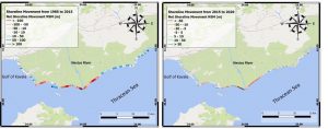
Net Shoreline Movement estimated; a) for the period 1985 to 2015 (left), and b) for the period 2015 to 2020 (right)