Group of Activities 1 (GA) — PONTOS platform development & Implementation in pilot areas
Activity 1.1 PONTOS platform development
This is a service-based open (i.e. freely accessible) platform to support environmental monitoring in the Black Sea area.
Structural components are developed in the following tasks:
Task 1: Back-end infrastructure. PONTOS platform is designed and developed to be able to: automatically retrieve and manage satellite, airborne, models, and in-situ data; automatically retrieve and utilize existing maps from the Copernicus and other national repositories, and allow data uploads from end-users. The database generated is an open-source object-relational spatial database.
Task 2: Enablers for input data update. The proposed monitoring framework is capable of retrieving existing satellite data (e.g. from the Copernicus Open Access Hub) and products from big data repositories (e.g. Copernicus Land Service, Copernicus Marine Environmental Service, etc.). For a finer resolution and better quality of delivered services, Copernicus products are combined with higher resolution airborne data and/or other in-situ collected data from existing monitoring infrastructures for the area of interest.
Task 3: Information and knowledge integration. EODESM combines any remote sensing or other spatial datasets (including modeled output) at any spatial and time scale of selection to automatically generate land cover characterization; and performs quantitative (where possible), objective, and traceable change detection.
Task 4: An interactive data interface. Task 4 enables the presentation of the data, information, and meta-information in a user-friendly (GUI) and accessible manner. Data thesaurus is delivered at various levels of information depth, depending on the request and data available. Open source solutions and plug and play functionality are preferred.
Task 5: Assessment of the Quality of Experience by the user. Quality of Experience of the PONTOS services by the users provide iterative continuous feedback for services’ improvement, debugging, and emerging needs satisfaction.
Activity 1.2 — Implementation in pilot areas
To access the Interactive Map, please click.
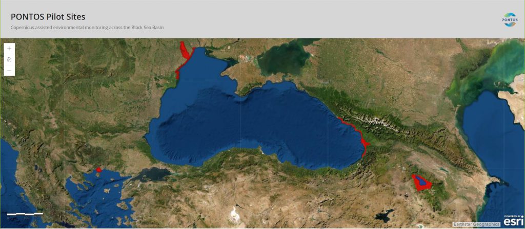
The methodology developed in GA 1 is implemented in the selected pilot areas. Tasks in this activity serve the need for environmental monitoring by the development of a Copernicus assisted monitoring strategy for each area, coordinate and exchange of knowledge and experiences across the pilots, application of the strategy at each area, and perform an integrated assessment for the areas according to the expected output.
Ukrainian Pilot area (PONTOS-UA) is located in the north-western part of the Black Sea consisting of two joint study sub-areas: the coastal line (PONTOS-UA_1) and the Dniester river delta (PONTOS-UA_2). PONTOS-UA_1 includes the best beaches and recreational areas in the south of Ukraine (UA) from Odesa city to the Danube river delta (approx. 170 km long). The main specific problems are coastal erosion and nutrient pollution (via riverine input, municipal wastewater discharge, and reactive N (Nr) deposition from land-based sources). PONTOS-UA_2 includes the Dniester river delta area and adjacent estuary (approx. 1800 km2) through which it is connected with the Black Sea; a significant part of this area belongs to the Lower Dniester National Nature Park. Main specific problems are nutrient pollution (from the agricultural sector (NO3- leaching, surface run-off, local Nr emission with further re-deposition ), municipal and industrial wastewater discharge) impacting drinking and irrigation water quality (via eutrophication, algal blooms, floating plants blooms, etc), natural fires/ burning of wetlands, river water discharge perturbation (due to hydropower station impact) with all consequences mentioned above.
Georgian Pilot area (PONTOS-GE) is located in the east part of the Black Sea consisting of two joint studies sub-sites the coastal line (PONTOS-GE_1) and the Kolkheti (Colcheti) Lowlands (West Georgia) (PONTOS-GE_2). PONTOS-GE_1 includes the entire coastline of Georgia (GE) (approx. 351 km long). This coastal area is under threat of severe coastal erosion caused by a combination of sea-level rise, the tectonic sinking of the land, alteration of the river, and the sediment flow. All this leads to shoreline recession. PONTOS-GE_2 covers the downstream part of the Rioni river, including the delta area and Kolkheti National Park (Ramsar site from 1996, Emerald site) (approx. 600 km2). Main specific problems are similar to those of PONTOS-UA sub-sites, however, regionally specific issues take place. Construction of several regulating dams and reservoirs in the Rioni Basin caused a reduction of the river and sedimentation flow dramatically impacting the delta area and natural habitats within. This was aggravated by the extraction of sediment and exploitation of river bed quarries for sand that led to river sediment loss in the estuary. Deforestation/ land cover change is another big issue in that region. Spawning sites of Sturgeon species (including Atlantic sturgeon) were severely degraded or lost.
Armenian Pilot area (PONTOS-RA) is the only in-land area without direct connection to the Black Sea located in the eastern part of the basin. This includes Sevan Lake, the largest source of freshwater for Armenia (AM), and its catchment area (approx. 5354 km2). The main problems are similar to those of river delta sites of aforementioned Pilot areas, including nutrient pollution, insufficiently treated wastewaters, biodiversity loss, perturbation of ecosystem functioning, illegal fishing, etc. Moreover, land cover changes due to water level changes, and urban encroachment is a major challenge.
Greek Pilot area (PONTOS-GR) is located in the Greek part of Nestos River, its Delta, and the coastal zone close to the Delta (approx. 2700 km2). The main problems are similar to those of river delta sites of UA and GE, such as long-term nutrient pollution from the agricultural sector, municipal and industrial wastewater discharge, anthropogenic perturbation of ecosystem functioning.
Group of Activities 2 (GA) — Capacity Building Activities
An essential ingredient for enhancing the use of Copernicus products and services for the environmental monitoring of the Black Sea is to enable and enhance participation, knowledge, and skills of most possible local and regional actors, from scientists to government employees and citizens. The goal of GA2 is to build capacity for utilization of Copernicus products and services in a coordinated manner through the PONTOS platform and online services tools. EO based capabilities for environmental monitoring are accessible, understandable and a credible option to use for environmental monitoring for the BSB.
The activities include a dedicated knowledge gap analysis and training strategy development, a training for trainers seminar among the PPs personnel to achieve leveling of capacity among partners and promote a multiplier and self-sustaining effect, the development of training material, the implementation of schooling events towards local actors (Activity 2.1), the adjustment of the capacity building actions to each Entity’s needs (Activity 2.2) and showcasing how PONTOS may offer self-operated solutions at ones working routine. Best tutoring and information transfer ways are being pursued, i.e. organization of seminars or at ones’ premises visits by PPs’ trained personnel. These activities relate directly to Objective 3, which provides for the engagement of local and regional actors at multiple levels as co-designers and receptors of the benefits accrued by PONTOS.
GA2 is structured around two main audiences:
Activity 2.1 — Capacity Building for Young Scientists and Practitioners
This activity provides for more specialized training tailored to the needs of young scientists, practitioners, and students. Training sessions for young scientists and practitioners are undertaken via a combination of on-site and virtual training. This activity targets young audiences who are expected to ensure the long-term sustainability of project results. During the project, 8 3-days training sessions are organized in total, 2 in each involved pilot area. Topics are related to environmental assessments and monitoring capabilities using EO products and methods. In particular, the sessions deepen the knowledge of the participants in the following aspects: 1) advances in EO services in environmental monitoring (1st session), and 2) PONTOS methodology and tools exploitation, as implemented and studied within the pilots (A.2.1) (2nd session).
Activity 2.2 — Capacity Building for Public Administration, Civil Society Organizations and Private sector actors
The activity aims at tailor-made capacity building of state and private-sector employees (local, national, regional governmental actors, NGO members, SME entrepreneurs, higher-level administration personnel), based on their real operational or market needs.