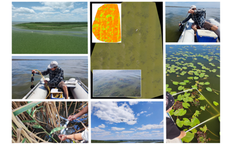
The Ukrainian pilot area (PONTOS-UA) is located in the northwestern part of the Black Sea and consists of two sub-areas: the coastline and the Dniester river delta.
The coastline includes the most popular beaches and recreational areas in the south of Ukraine, from the city of Odessa to the Danube Delta. A significant part of the Dniester Delta is included in the Lower Dniester National Nature Park. The river is connected to the Black Sea through the adjacent Dniester Estuary, which is of great ecological and economic importance to the region.
The pilot area faces challenges such as coastal erosion, nutrient pollution affecting drinking and irrigation water quality and ecosystems, disruption of river water flow (due to impacts of hydropower plants) affecting habitats/biodiversity and agricultural water supply, forest fires and wetland burning.
Within the framework of the PONTOS project, Odessa National I.I. Mechnikov University actively involved stakeholders in cooperation, informed them about achievements, developments and gained experience, and identified their requirements and wishes. For this purpose, an online meeting of potential stakeholders (brainstorming event) was held in the summer of 2021. The aim of the event was not only to inform the stakeholders about the project progress, but also to present the PONTOS platform and its tools to improve the capacity to use Earth Observation (EO) data. The participants represented all target groups of the project: national, regional and local authorities, sectoral agencies, small and medium enterprises, business support organizations, non-governmental organizations, academic and research institutions, and international organizations. All participants underlined the important role of the PONTOS project, as the global problems faced by the countries of the Black Sea basin urgently require joint action and cross-border cooperation.
In order to increase the capacity of in the EO data use, the Ukrainian participants attended the workshops organized by the project in the framework of the four planned assessments: (і) Coastline Dynamics Assessment, (іі) Wetland and Floating Vegetation Cover Assessment, (ііі) Integrated Assessment of Chlorophyll Concentration and Eutrophication Dynamics, (іv) Assessment of Water Balance and Water Stress Indices in Agroecosystems.
The report on the dynamics of coastal line changes is planned to be completed in October 2021 and will be available to the public shortly thereafter. Until then, we need to highlight a few important points:
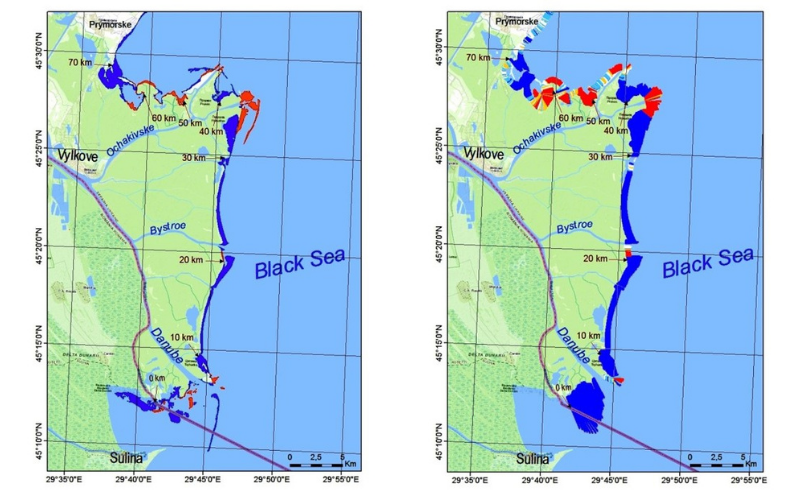
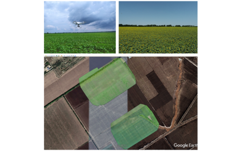
- Landsat imagery for 1980-2020 (with a 5-year increment) was processed using the DSAS tool using the modified approach developed by DUTH.
- The modified DSAS method was found to be more effective (2-3-fold) compared to a conventional GIS method.
- For complicated riparian areas with high tortuosity and high erosion/accumulation rates, processing time increases because more time is required for ‘manual’ review and correction of DSAS results using the additional software GIS.
- Preliminary analyses have shown that two areas – the Danube Delta (1) and Odessa Bay (5) – have maximum erosion and accretion rates. Therefore, these two areas are of particular interest to both scientists and stakeholders.
The project will conduct field investigations in the Ukrainian pilot area. The field surveys in the Dniester Delta (Dniester Estuary and Lake Bile) were conducted in April, June, July, August and September 2021 using ONU’s transport and equipment (four-wheel-drive vehicle, boats, field instruments and tools for sampling and monitoring). During each survey, the following was conducted:
- Observation and measurement of hydrological and physicochemical parameters of the water;
- Water sampling to determine chlorophyll concentration and hydro chemical composition in the laboratory;
- Mapping of the water surface to identify vegetation cover (different vegetation types) using the UAV (quadcopter) purchased with the project funds and partly involving the ONU multispectral UAV;
- Sampling of plants to identify phenological characteristics.
All data collected will be used to determine the spatial and temporal distribution of chlorophyll concentrations – reasons, causes, dynamics and consequences of eutrophication phenomena in the context of assessment (ііі), to determine vegetation cover and boundaries of different types of aquatic vegetation in the context of assessment (іі), and to validate/improve the quality of some EO data (space imagery/space-derived products) interpreted for the pilot area by comparing the real condition of the area and its ‘reflection’ by the space-derived products. In the future, this will help to save resources (time, money, effort, etc.) for environmental monitoring. The results of the validation will be used for the development of the interactive PONTOS platform tools, which will be made available to the public.
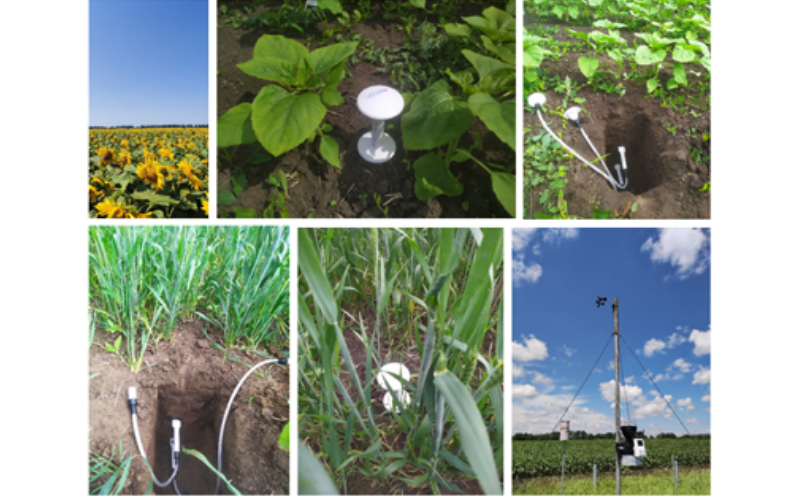
For the assessment (iv) of agricultural water balance and water stress indices, wheat and sunflower were selected from the typical spring crops as the most common crops in Odessa region in 2019; two representative fields were selected. The works carried out included:
- Installation of soil moisture and temperature loggers in the soil profile at both sites using the ONU vehicle and equipment;
- Deployment of ONU’s automated weather station at one of the fields;
- Conducting regular aerial observations (May-September) using the UAV (quadcopter) purchased from the project funds and partly involving ONU’s multispectral UAV;
- Sampling of vegetation (in July) to determine wet and dry biomass.
To perform the Assessment (iv) of agricultural water balance and water stress indices, out of typical spring crops wheat and sunflower were selected as the most frequent crops in Odessa Region in 2019; two representative fields were chosen. The work done comprised:
- Installation of soil moisture and temperature loggers in the soil profile at both sites using the ONU vehicle and equipment;
- Use of the ONU’s automatic weather station on one of the fields;
- Performing of regular (May-September) aerial observations using the UAV (quadcopter) purchased through the Project funds and partially involving the ONU’s multispectral UAV;
- Sampling of vegetation (in July) to determine wet and dry biomass.
Apart from its value for the economy of the region and the country, as well as for the well-being of the local population, the pilot area of the project also has great cultural and ecological significance. It includes protected areas, including Ramsar wetlands of international importance. These areas are characterized by rich flora and fauna, fish spawning areas, bird nesting sites and beautiful landscapes. ONU researchers – the project participants – are therefore doing their best to preserve this picturesque corner of Ukraine for future generations.
-
- The shoreline evolution in the Danube delta over 1980-2020 [left image: coastal area changes map.
-
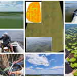
- Field measurements, sampling and mapping in the Dniester mouth and adjacent estuary (photo credit: Sergiy Medinets).
-
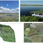
- Field measurement, sampling and mapping in Bile Lake (photo credit: Sergiy Medinets).
-
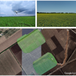
- UAV mapping of the wheat and sunflower fields studied (photo credit: Sergiy Medinets).
-
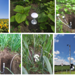
- installation of soil moisture and temperature metres and an automatic weather station in the studied fields (photo credit: Sergiy Medinets).