The event was organized by Ukrainian PONTOS team, the staff of the Regional Centre for Integrated Monitoring and Environmental Studies (RCIMES) of Odesa National I.I. Mechnikov University (ONU), and held online on October 27 and 28, 2021. The training participants represented regional and local administrations, NGO, water management and nature conservation bodies, however the topic rose the highest interest in the younger generation – young lecturers, researchers, postgraduates, master students and, of course, practitioners working in the Ukrainian pilot area. Overall, 50 participants attended this event.
In his welcoming speech Dr. Volodymyr Medinets, Director of the RCIMES ONU, pointed out that Earth Observation (EO) data are, no doubt, a great breakthrough and an incredible resource to follow the dynamics of numerous parameters at local-to-global scale. However, accuracy of the EO data requires thorough validation using in-situ data.
At the beginning of the training Dr. Sergiy Medinets, leader of Ukrainian PONTOS team, briefly reminded the participants of the PONTOS Project objectives, expected results and the activities planned in Ukrainian pilot area.
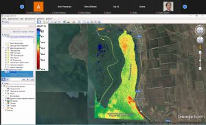
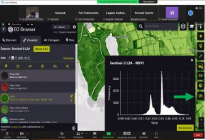
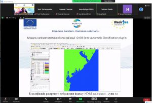
The first session was dedicated to the EО technologies and Copernicus products. Presentation on modern EO technologies, their use for environmental monitoring and assessment, the Copernicus products and services was delivered by Yevhen Gazyetov, ONU researcher. His second presentation was dedicated to Copernicus Open Access Hub and Sentinel Hub. The next presentation, made by Tetiana Pavlik, ONU researcher, covered the USGS Digital Shoreline Analysis System (DSAS) use for shoreline changes calculation. After that, Yevhen explained the use of the ESA Sentinel Application Platform (SNAP) and Sentinel Toolboxes.
During the practical session dedicated to work with SNAP and DSAS, Yevhen was teaching the participants to calculate chlorophyll concentration and NDVI indices using SNAP and Tatiana showed how to build shorelines using QGIS and calculate statistical parameters of their changes with DSAS.
In the end of the training, the participants received information on how to install and use the EarthTrack mobile application developed to support near real time data collection on land cover for Earth Observation Data for Ecosystem Monitoring (EODESM) system.
The training has demonstrated great potential of EO daily use for almost everyone, from a student to a regional authority representative. EO is a source of objective information to monitor the environment and can rise the stakeholder’s awareness on its state significantly, especially in the Black Sea Basin countries, in most of which the in-situ environmental monitoring network is still underdeveloped.
Unfortunately, the practical work in field planned for the third day of the training had to be postponed due to the current local epidemiological situation with COVID-19 in Odesa region. The practical training in the field will be included into the next training session, which will take place in May-June 2022.
The Ukrainian version of the article is available here.
Training material, resources and recordings are available here.